ORT-Eng

Acuíferos Transfronterizos: Desafíos Y El Camino a Seguir

Alcanzando Acuerdos Sobre Aguas Subterráneas en La Frontera Entre México Y Estados Unidos: Fundamentos Científicos Y Políticos

November 07, 2022
Transboundary Aquifers Challenges and the way forward
Rosario Sánchez ed.
Roberto Salmon
Elia M. Tapia-Villaseñor
Mary-Belle Cruz
pages 46-51
247 pp.
UNESCO
Paris, France
Transboundary Aquifers cover

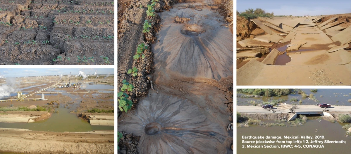
El agua subterránea es vital para la sostenibilidad y supervivencia de las comunidades humanas en la región fronteriza entre Estados Unidos y México, una zona árida de casi 2000 millas de longitud en América del Norte donde prevalece la incertidumbre climática. Se conocen más de 30 acuíferos que limitan o atraviesan la frontera internacional, sustentando una población fronteriza que superaba los 15 millones de habitantes en 2020 (Figura 1). El agua subterránea es la única o principal fuente de agua para más de una docena de ciudades hermanas o comunidades, que van desde una de las zonas metropolitanas binacionales más grandes, El Paso-Cd. Juárez, hasta la próspera metrópolis binacional de Ambos Nogales, pasando por comunidades más pequeñas contiguas en la frontera occidental y a lo largo del río Grande. Desafortunadamente, la utilización del agua subterránea está regulada por un acuerdo internacional en solo una pequeña zona, la Mesa de San Luis, a lo largo de la frontera sur. Ese acuerdo, firmado en 1973, señaló la necesidad de un acuerdo integral sobre agua subterránea para la región fronteriza, un objetivo que ha eludido a los dos países durante casi medio siglo. Este documento examina la perspectiva de alcanzar acuerdos adicionales sobre agua subterránea entre los dos países. En primer lugar, considera el marco institucional que da forma a la cooperación binacional en la gestión transfronteriza del agua subterránea. Luego, revisa los avances en la cooperación técnica y científica binacional sobre agua transfronteriza relevante para los acuíferos compartidos. Continúa considerando cómo los principios y prácticas diplomáticas emergentes pueden facilitar enfoques cooperativos para gestionar los acuíferos compartidos a lo largo de la frontera entre Estados Unidos y México, basándose en la experiencia reciente en evaluación de agua subterránea obtenida a través del compromiso binacional en el Programa de Evaluación de Acuíferos Transfronterizos. El documento concluye identificando los principios y prácticas que son más propicios para avanzar en la colaboración binacional en la gestión de acuíferos transfronterizos para utilizar estos recursos esenciales de manera más sostenible.

TAAP - Other Relevant Topics
Make content full-width
half
Yearly (use the format YYYY)

Transboundary Aquifers: Challenges and the way forward

Reaching Groundwater Agreements on the Border Between Mexico and the United States: Science and Policy Fundamentals

November 07, 2022
Transboundary Aquifers Challenges and the way forward
Rosario Sánchez ed.
Roberto Salmon
Elia M. Tapia-Villaseñor
Mary-Belle Cruz
pages 46-51
247 pp.
UNESCO
Paris, France
Transboundary Aquifers cover

Groundwater is vital to the sustainability and survival of human communities in the U.S.-Mexico border region, a nearly 2000 mile-long, arid zone in North America where climate uncertainty prevails. More than 30 aquifers are known to abut or span the international boundary, supporting a border area population exceeding 15 million persons in 2020 (Figure 1). Groundwater is the sole or principal water source for more that half-a-dozen sister cities or communities ranging from one of the largest binational metropolitan zones, El Paso-Cd. Juarez, to the thriving binational metropolis of Ambos Nogales, to smaller coadjacent communities on the western land boundary and along the Rio Grande River. Unfortunately, groundwater utilization is regulated by international agreement in just one small area, the San Luis Mesa, along the southerly international boundary. That agreement, signed in 1973, noted the need for a comprehensive groundwater agreement for the border region, a goal that has eluded the two countries for nearly half a century. This paper examines the prospect of reaching additional groundwater agreements between the two countries. It first considers the institutional setting shaping binational cooperation on transboundary groundwater management. It then reviews advances in binational technical and scientific cooperation on transboundary water relevant to shared aquifers. It follows by considering how emerging diplomatic principles and practices may facilitate cooperative approaches to managing shared aquifers along the U.S.-Mexico boundary, drawing on recent experience in groundwater assessment gained from binational engagement in the Transboundary Aquifer Assessment Program. The paper concludes by identifying principles and practices that are most conducive to advancing binational collaboration on transboundary aquifer management to utilize these essential resources more sustainably.

TAAP - Other Relevant Topics
Make content full-width
half
Yearly (use the format YYYY)

Reflections: On April 4, Easter, and the Earthquake

April 09, 2021
Reflections
2 pp.
Water Resources Research Center
Tucson, AZ
mexicali valley

In 2021, the Easter holiday once again fell on April 4, which happens to be my birthday. This coincidence previously happened in 1999 and 2010. For different reasons, I think back to both. In 1999, Tucson, Arizona experienced snow on Easter morning. The highly unusual April snowfall was beautiful and brief, with all signs of snow quickly disappearing as the sun came out and temperatures warmed. A very different natural phenomenon occurred during the afternoon hours of Easter 2010; a devastating earthquake lasting about 1.5 minutes hit northwestern Mexico and southern California. Measuring 7.2 on the moment magnitude scale, the 2010 Easter earthquake inflicted terrible damage, including destruction of water delivery infrastructure in Mexico.

I often refer to the Easter earthquake when I point out drivers of water policy changes. Because many water users in Mexico were unable to receive and use Colorado River water, a major shift resulted in United States-Mexico water collaboration. In the interest of binational cooperation, for the first time, the U.S. allowed Mexico to store water in Lake Mead, the large reservoir heretofore used to store water for the Lower Colorado River Basin states (Arizona, California, and Nevada). This action set the foundation for innovative binational collaboration through numerous Minutes to the 1944 Treaty for Utilization of Waters from the Colorado and Tijuana Rivers and of the Rio Grande between the United States and Mexico. 

Minutes, which are binding interpretations of the 1944 Treaty, are approved by the Commissioners of the U.S. and Mexican Sections of the International Boundary and Water Commission (IBWC). At the time of the earthquake, Roberto Salmón was just one year into his term as Mexican Section Commissioner. Commissioner of the U.S. Section, Edward Drusina, was less than three months into his position. 

In response to this natural disaster, the IBWC Commissioners, staff, and stakeholders got to work on mitigating earthquake impacts. On June 17, 2010, the Commissioners signed Minute 317, “Conceptual Framework for U.S.-Mexico Discussions on Colorado River Cooperative Actions,” in which they agreed to establish a binational Consultative Council to consider legal, administrative, and policy matters associated with cooperative actions. The Consultative Council could receive assistance from the binational Core Group and any relevant binational Work Group. Importantly, through this process, the Commission would “explore opportunities for binational cooperative projects that: minimize the impacts of potential Colorado River shortage conditions; generate additional volumes of water using new water sources by investing in infrastructure such as desalinization facilities; conserve water through investments in a variety of current and potential uses, including agriculture, among others; and envision the possibility of permitting Mexico to use U.S. infrastructure to store water.”

Following many binational meetings, six months later, on December 17, 2010, the Commissioners signed Minute 318, “Adjustment of Delivery Schedules for Water Allotted to Mexico for the Years 2010 through 2013 as a Result of Infrastructure Damage in Irrigation District 014, Rio Colorado, Caused by the April 2010 Earthquake in the Mexicali Valley, Baja California.” This Minute established an accounting protocol for water left in Lake Mead in lieu of physical delivery to Mexico per the 1944 Treaty. What followed from Minute 317’s cooperative framework is perhaps the most well-known of the Minutes addressing Colorado River water matters – Minute 319. Though modestly entitled “Interim International Cooperative Measures in the Colorado River Basin through 2017 and Extension of Minute 318 Cooperative Measures to Address the Continued Effects of the April 2010 Earthquake in the Mexicali Valley, Baja California,” Minute 319 contained path-breaking provisions. Because I cannot describe these provisions better than the fact sheet on it, I reproduce the bullets here:

  • Establishes proactive basin operations through the sharing of benefits of water that may be available temporarily through high Lake Mead reservoir conditions and also reducing water delivery when reservoir conditions are low in order to reduce the risk of more severe reductions in the future.
  • Establishes a program of Intentionally Created Mexican Allocation (ICMA) whereby Mexican water resulting from conservation and new water sources projects could essentially be held in the United States for subsequent delivery to Mexico in the future.
  • Implements measures to address salinity impacts stemming from the joint cooperative actions.
  • Through conservation projects generates water for the environment of the Colorado River limitrophe (boundary segment) and delta.
  • Establishes a pilot exchange program under which U.S. entities assist in funding water infrastructure and environmental projects in Mexico. These investments provide water benefits to the U.S. agencies in exchange for their funding and generate water for Mexico over the long term.
  • Outlines potential opportunities for future cooperation between the United States and Mexico on topics such as environmental restoration, water conservation, system operations, and new water sources projects.
  • Establishes the expectation that the Commission will conclude another agreement in the future to extend or replace the substantive provisions of Minute 319.

Importantly, Minute 319 enabled the famously impactful 2014 pulse flow, when Colorado River water flowed in its natural path all the way to the river’s delta. This immensely collaborative effort included binational representatives from federal and state governments, water utilities, NGOs, and universities.

Established as an interim Minute, Minute 319 was succeeded by Minute 323, “Extension of Cooperative Measures and Adoption of a Binational Water Scarcity Contingency Plan in the Colorado River Basin.” In addition to extending the cooperative and complex activities related to binational sharing of Colorado River shortage and surplus, Minute 323 established an Environmental Working Group and resulted in the first binational study of desalination opportunities in the Sea of Cortez. 

In my recent discussions of Wicked Water Problems, I emphasize functioning collaborative mechanisms as important contributors to developing pathways to solutions. Wicked water problems, such as surface water shortages and the imbalance between water supply and demand, were precisely the complex challenges faced by the Colorado River Basin. In these discussions, I also express hope that we address challenges proactively and not wait for a crisis to develop. However, some crises, such as the Easter Earthquake, cannot be predicted. What is notable is how the preexisting binational mechanism for collaboration – the International Boundary and Water Commission – was able to spring into action after disaster hit.

Bringing us back to Easter events, April 4, 2021 was another notable weather day – at least in Tucson. The temperature hit 96 degrees Fahrenheit, a record for the day. Following on 2020, Arizona’s driest year on record and second hottest year, 2021 does not look to be a good year for Colorado River runoff. At a time when hydrologic conditions suggest that a Lower Colorado River Basin Tier 1 shortage declaration is highly likely as soon as 2022, we can be thankful for the strong, foundational binational mechanisms and agreements already in place.

TAAP - Other Relevant Topics
Program
Make content full-width
full
Daily (use the format Month, XX YYYY)