By Ashley Hullinger, WRRC Research Analyst
Question: What kind of effort and time go into the making of the WRRC Arizona Water Map?
Image

Answer: More than you might expect! In terms of effort, four WRRC personnel completed research and tasks at varying stages of map development and relied upon the volunteer hours of dozens of supporters. Approximately one year and six months later, we are all proud of the outcome.
 From brainstorming to final reviews, the power of the stakeholder-driven process was harnessed to ensure that the fourth version of the Water Map accurately reflects the current state of water resources in Arizona, as well as a culture of management and planning unique to our state. While WRRC-internal conversations started a few months before, the map was propelled forwarded by the formation of the Arizona Water Map Technical Advisory Committee (TAC), convened on the basis of GIS expertise, experience with Arizona water resources data, and involvement in previous Arizona Water Map development. The TAC included representatives from the Arizona Department of Environmental Quality, Arizona Department of Water Resources, Central Arizona Project, Salt River Project, U.S. Bureau of Reclamation, University of Arizona, Water Infrastructure Finance Authority of Arizona, and Water Resources Research Center.
The first stakeholder meeting and an online survey were conducted in October 2015, posing questions about the usefulness of past maps and possible areas of improvement. A plan of attack was formed. The first step was to compile all of the suggestions and feedback from the meeting and survey to ask three pointed questions of the WRRC External Advisory Committee in November of 2015:
- Which of the three previous Arizona water maps is most visually appealing? Why?
- Is the question, “Are we going to run out of water?” a valid and useful organizing theme for this map?
- What would you consider to be the 7-10 most important Arizona water features to include on a static map of the state?
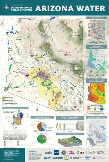
Responses were tabulated, and with an array of responses in hand, the WRRC and TAC put the map through multiple stages of design and review. The TAC provided vital guidance and expertise throughout the map development process, which was then taken back to the WRRC drawing board for synthesis. Notable updates and changes to the final map included:
- Stronger emphasis on water supply and demand in Arizona, among different water using sectors and regions
- Inclusion of ADWR’s 22 planning areas used in their statewide planning initiative released in the 2014 Strategic Vision
- Updated data
- Updated appearance to reflects modern design technique
- Emphasis on groundwater usage
- Highlighted population density
- New map on recharge and subsidence
- New natural terrain background using Esri’s multi-directional hillshade, which presents mountains, plateaus, valleys and canyons using an algorithm that computes hillshade from six different directions (as opposed to one direction in a default hillshade)
- We look forward to sharing the latest map throughout the state, continuing a tradition of providing reliable and concise visual representation of Arizona's water resources.
Throughout the course of map development we welcomed the support of sponsors and partners, to whom we are extremely grateful. Their logos are displayed at the bottom of the map, and they include the Arizona Department of Water Resources, Arizona Municipal Water Users Association, Arizona Public Service, Arizona Project WET, Arizona Cooperative Extension, Central Arizona Project, EPCOR Water, Jacobs Engineering, Salt River Project, Sonoran Institute, The Nature Conservancy, U.S. Bureau of Reclamation, University of Arizona Research, Discovery & Innovation, and Water Resources Research Act §104(b) program.
Beginning in May, maps will be on sale at the Water Resources Research Center and can be ordered by emailing us a wrrc@email.arizona.edu or calling 520-621-9591. Contact us now to preorder.

