
The climate of the southwest United States can be a little bit deceiving at first glance. Warm and dry conditions are a pretty good bet on any given day, but if you look at precipitation records over years to decades you will notice some dramatic swings from very wet one year to very dry the next. This is what climatologists call interannual climate variability. When examining long-term precipitation records for Arizona and New Mexico, much of this interannual variability, in the winter season especially, can be tied back to a climate phenomenon called the El Niño-Southern Oscillation (ENSO). ENSO is a somewhat regular (on the order of 2 to 7 years) shift in sea surface temperatures along the equator of the Pacific Ocean basin. Normally, temperatures are cooler in the eastern Pacific and warmer in the western Pacific due to easterly winds causing upwelling of cool water in the east and the movement of warmer surface water to the west. In
some years, stronger than average easterly winds will intensify this pattern of cool east-—warm west sea surface temperatures, which is termed a La Niña event. During El Niño events these easterly winds weaken, causing warm water to slosh back to the central and eastern Pacific with warmer than average sea surface temperatures in these regions. The location and extent of warm sea surface temperatures (SSTs) is critical in determining where tropical thunderstorms occur and in turn their impact on global circulation patterns. Across the continental United States the impact of ENSO is strongest during the winter season when the storm track, driven by the position of the jet stream, is typically disrupted and precipitation anomalies emerge. During El Niño events, the winter jet stream often splits in the east Pacific with a stronger than average subtropical jet stream that steers a parade of storms across the southern states and subsequently above-average precipitation (see figure page 6). In contrast, during La Niña events the winter storm track is more likely to enter the Pacific Northwest, bringing above average precipitation to this region and leaving the southwest U.S. with below-average winter precipitation.
 Our understanding of the impact of El Niño events on seasonal climate has improved considerably over the last few decades. In particular, we can often detect the development of an El Niño event months in advance, long before it will ever have an impact on seasonal weather conditions. For Arizona and New Mexico, an El Niño event means increased probability of receiving above-average winter precipitation, generally between October and March. However, there is still plenty of variability when comparing El Niño events, and there is no guarantee that any given El Niño event will lead to wetter than average conditions. Unfortunately, knowing that an El Niño event, even a strong one, will be present over the winter is not a slam-dunk wet forecast for the Southwest. The very strong El Niño event of 2016 has been very instructive in this point.
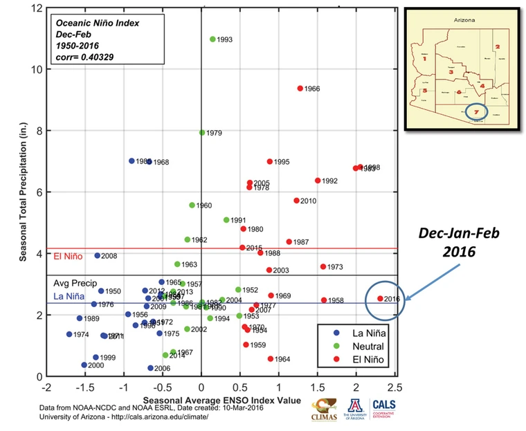
To illustrate, the figure below is a scatterplot of total December-January-February precipitation for southern Arizona (climate division 7 to be more specific) for every year from 1950-2016 plotted against the strength of a common ENSO index called the Oceanic Niño Index (simply how different the SSTs are from average in the central-eastern Pacific Ocean). In general, you may notice a rough organization of the blue points or La Niña years on the lower end of the precipitation scale and the red with more spread and reaching into the higher values of total Dec-Jan-Feb total precipitation. Interestingly the blue-dot/La Niña years pretty much all fall below the average level of Dec-Jan-Feb precipitation, which is consistent with our understanding of the winter storm track being shifted north away from Arizona. The red dot/El Niño years are a bit more of a mess with some below-average years and many above. The stronger events, especially 1983 and 1998, were quite a bit above-average which gave us some hope that 2016, which was even a touch stronger, would be above-average as well. Unfortunately, 2016 charted its own path and reinforced the point that the El Niño is not a guarantee of above-average winter precipitation and only tilts the odds in that direction. The winter storm track in 2016 was displaced north, much as during a typical La Niña winter, keeping the expected precipitation in the Pacific Northwest and northern California rather than in the Southwest. It is unclear why this El Niño behaved so differently from past strong events, but will no doubt be an active area of research over the next several years. Regardless, future El Niño events will assuredly bring wet conditions, but not all of them. This is part of living in a region with large amounts of climate variability, being ready to be surprised by both the wet and the dry.